
WHERE IS EARTH'S WATER?
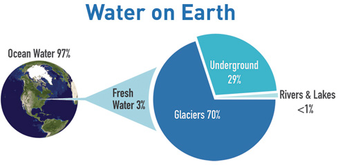
Despite covering nearly three-quarters of the planet, water is a limited natural resource. Our oceans are expansive, however, even this volume of water accounts for only a thin film of water on Earth’s surface. It may be a surprise, but only three percent of Earth's water is freshwater and almost all of it is locked up in glaciers or in groundwater. Only about one percent of all fresh water on the planet is surface water that can be accessed by most living organisms including us. Our lakes, rivers, soil, and atmosphere carry this water through the world’s ecosystems continuously, yet pollution introduced along the way can impact whether that water can continue to support the life that depends on it.
The United States Geologic Service (USGS) has great resources on where you can find all of Earth’s water resources. Read on to learn more at the Water Science School.
It's all Connected
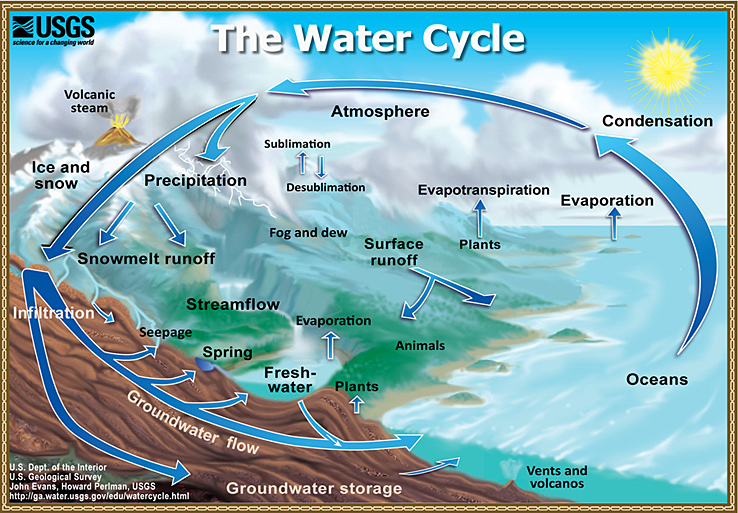
The water cycle has no starting point, but we'll begin in the oceans, since that is where most of Earth's water exists. The sun, which drives the water cycle, heats water in the oceans. Some of it evaporates as vapor into the air; a relatively smaller amount of moisture is added as ice and snow sublimate directly from the solid state into vapor. Rising air currents take the vapor up into the atmosphere, along with water from evapotranspiration, which is water transpired from plants and evaporated from the soil. The vapor rises into the air where cooler temperatures cause it to condense into clouds.
Air currents move clouds around the globe, and cloud particles collide, grow, and fall out of the sky as precipitation. Some precipitation falls as snow and can accumulate as ice caps and glaciers, which can store frozen water for thousands of years. Snowpacks in warmer climates often thaw and melt when spring arrives, and the melted water flows overland as snowmelt. Precipitation falls back into the oceans or onto land, where, due to gravity, it flows over the ground as surface runoff. A portion of runoff enters rivers in valleys in the landscape, with streamflow moving water towards the oceans. Runoff and groundwater seepage accumulate and are stored as freshwater in lakes.
Not all runoff flows into rivers, though. Much of it soaks into the ground as infiltration. Some of the water infiltrates into the ground and replenishes aquifers(saturated subsurface rock), which store huge amounts of freshwater for long periods of time. Some infiltration stays close to the land surface and can seep back into surface-water bodies (and the ocean) as groundwater discharge, and some groundwater finds openings in the land surface and emerges as freshwater springs. Yet more groundwater is absorbed by plant roots to end up as evapotranspiration from the leaves. Over time, though, all of this water keeps moving, some to reenter the ocean, where the water cycle continues, indefinitely.
What is a Watershed?
Every bit of land on Earth is part of a watershed. Specifically, a watershed is a geographically defined area of land that contains streams and rivers that all drain into a single body of water, such as a lake or the ocean. Watersheds can be big or small, but they all have high points like ridges and mountains that capture precipitation, store it as either surface water or groundwater, and eventually release it downhill. Our actions on the land and in our rivers impact the health of our watersheds. As rivers flow through our communities, they collect contaminants along the way, making the ocean the final resting place for much of the pollution and contaminants that have been carried downstream.

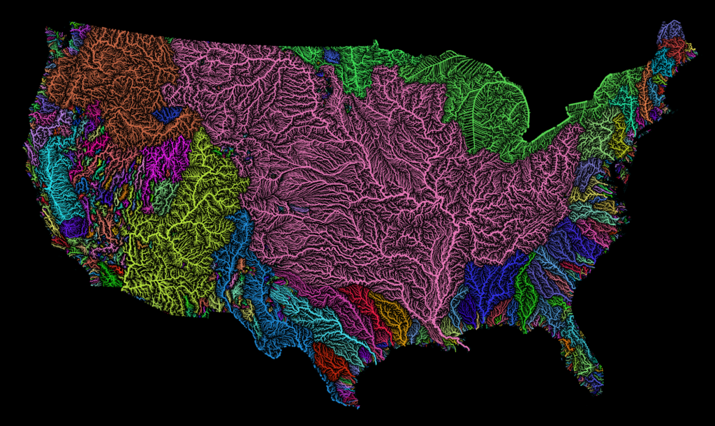
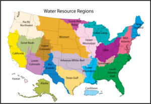
North American River Basins
On a broader scale, a watershed is defined by its hydrologic, geomorphologic, and climatologic characteristics - how much water is present, the landforms that influence water’s movement, and the temperature and precipitation patterns that drive plant and wildlife diversity.
Of the 50 United States, 23 are coastal and 7 border the Great Lakes. A few states contain major watersheds that are entirely landlocked, but many others are located within basins that drain to the coasts. The Mississippi/Atchafalaya River Basin (seen in the image here as the large pink area) receives water from rivers in 31 different states plus two Canadian provinces. This watershed is the third largest in the world, covering over 1.2 million square miles. A watershed of this scale moves an enormous amount of water and has the potential to transfer contaminants into the Gulf of Mexico from as far away as the Northern Rocky Mountains.
Find your Hydrologic Unit Code (HUC)
Click the image to enter the USGS Locate your Watershed Page:
The United States is divided and subdivided into successively smaller hydrologic units which are classified into four levels: regions, sub-regions, accounting units, and cataloging units. The hydrologic units are arranged or nested within each other, from the largest geographic area (regions) to the smallest geographic area (cataloging units). Each hydrologic unit is identified by a unique hydrologic unit code (HUC) consisting of two to eight digits based on the four levels of classification in the hydrologic unit system. Think of a region-level watershed as the Mississippi/Atchafalaya River Basin and a watershed at the scale of a cataloging unit as the small stream in your local park.
The second level of classification divides the 21 regions into 221 subregions. A subregion includes the area drained by a river system, a reach of a river and its tributaries in that reach, a closed basin(s), or a group of streams forming a coastal drainage area. The first level of classification divides the Nation into 21 major geographic areas, or regions. These geographic areas contain either the drainage area of a major river, such as the Missouri region, or the combined drainage areas of a series of rivers, such as the Texas-Gulf region, which includes a number of rivers draining into the Gulf of Mexico. Eighteen of the regions occupy the land area of the conterminous United States. Alaska constitutes region 19, the Hawaii Islands are region 20, and Puerto Rico and other outlying Caribbean areas are region 21.
The third level of classification subdivides many of the subregions into accounting units. These 378 hydrologic accounting units are nested within or can be equivalent to the subregions.
The fourth level of classification is the cataloging unit, the smallest element in the hierarchy of hydrologic units. A cataloging unit is a geographic area representing part of all of a surface drainage basin, a combination of drainage basins, or a distinct hydrologic feature. These units subdivide the subregions and accounting units into smaller areas. There are 2264 Cataloging Units in the Nation. Cataloging Units sometimes are called "watersheds".
Storm Drains
Water entering storm drains flows directly to our rivers and streams unfiltered, meaning that, unlike household wastewater, storm drain water is not diverted to a treatment facility where it would be cleaned of its many contaminants. Therefore, when it rains, anything dumped on the ground, roads, sidewalks, and driveways is washed into storm drains where it then flows towards local water bodies, rivers, streams, and eventually to a reservoir, lake, or coast. This includes contaminants like pet feces, fertilizers from our yards, and chemicals from our cars such as leaked oil and detergents from washing cars in our driveways.

When you think of litter, what comes to mind? If it’s cigarette butts, that’s probably because they are the most common marine litter in America and they’ve been found in the stomachs of fish, birds, whales, and other creatures that mistake them for food. They have to enter the environment from somewhere, though, and whether the coast is nearby or far away, storm drains offer an easy route into the nearest water source.
Dog waste is considered to be toxic by the EPA. The droppings Fido leaves behind contain disease-causing bacteria that can make people and wildlife sick. Dog waste can carry E.coli, fecal coliform, salmonellosis, and other diseases. When it rains, dog waste is carried along with the runoff into storm drains and impacts creek and human health.
Washing your car can also have negative effects on our watersheds. If you wash your car in your driveway or a parking lot, the soapy water that washes off your car travels down the driveway and street and into the storm drain.
Dirty car wash water contains toxic pollutants from the car and the soap. Contrary to popular belief, this dirty wash water does not get cleaned at a wastewater treatment plant before it enters into the nearest stream, lake, or sound. These contaminants can harm fish and wildlife, pollute streams, lakes, and rivers, and even seep into our groundwater, an important source of drinking water.

Dead Zones
The amount of pollutants that accumulate as water travels downstream leads to diminished water quality. In some coastal areas, this becomes a big problem known as a hypoxic, or dead, zone. Oxygen-deprived hypoxic zones can occur naturally, but they are greatly enhanced by human activity. Excess nutrients are the primary cause of dead zones. Nutrients lead to an overgrowth of algae, which eventually decomposes in rivers or the ocean, and oxygen is required to decompose the excess algae, depleting the surrounding water of the oxygen needed to support life. Marine life then either flees if able or are left to suffocate.
There are over 550 dead zones worldwide, several of which can be found along the US East Coast and in the Great Lakes. The second-largest dead zone in the world is in the northern Gulf of Mexico where the mouth of the Mississippi—one of Colorado’s drainage points—enters the ocean.
Despite these ecological impacts, the Gulf of Mexico supplies over 40% of the United States’ domestic seafood and billions of dollars for fisheries and tourism economies (Environmental Defense Fund).
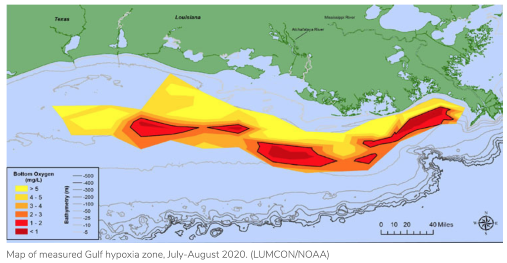
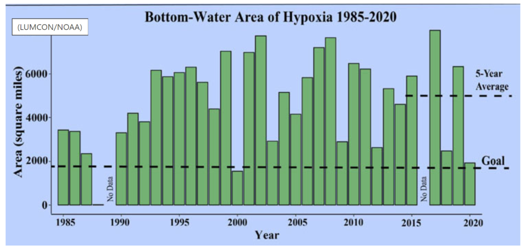
The impacts of dead zones can be devastating, both economically and environmentally. In Louisiana for example, the dead zone amounts to about 235,000 tons (470 million pounds) of seafood lost every year. Each year the size of dead zones shifts and grows, often in response to heavy spring precipitation in the Mississippi River watershed. In 2015 it was nearly 6,500 square miles, roughly the size of Connecticut and Rhode Island combined. The dead zone ranges anywhere from 4,500-8,500 square miles of ocean. In 2020, the Gulf of Mexico dead zone was measured at the third smallest size in 34 years of data recording, at 5,408 square miles. Although smaller than some years, this is still 2.8 times larger than the 2035 target set by the Hypoxia Task Force.
EPA Tracking
![]() Click to access the How's My Waterway application provided by the US Environmental Protection Agency to collect and deliver water quality information on individual watersheds.
Click to access the How's My Waterway application provided by the US Environmental Protection Agency to collect and deliver water quality information on individual watersheds.
USGS Monitoring
![]()
Click to enter the United States Geological Survey (USGS) National Water Information System web interface to see real-time streamflow information.